Tropical Storm Debby keeps moving. Here’s when it’ll hit Farmville.
Published 12:40 pm Wednesday, August 7, 2024

|
Getting your Trinity Audio player ready...
|
When will it hit? That’s the big question surrounding Tropical Storm Debby, as we’re expected to get some rain from the storm later today. But when will the storm itself actually hit? The National Weather Service has mapped out a rough timeline.
In preparation for the storm, the National Weather Service office in Wakefield has issued a flood watch for the region that extends through Friday night. Wednesday’s storm track shows Debby moving up from North Carolina and directly across southern and central Virginia during Friday. By 2 a.m. Friday, it should be at the Virginia state line. By 2 p.m. Friday, the remnants are expected to be directly passing over Central Virginia, heading straight up to Charlottesville and beyond. It’s a large enough storm that even after the main portion passes by, we’ll have rain for several hours, if not another full day.
Virginia Department of Emergency Management Deputy Communications Director and Chief Agency Spokesperson Jason Elmore said current forecasts call for three to six inches of rainfall between now and Saturday. Farmville, Cumberland and Prince Edward counties are expected to get the heavier side of that, closer to six inches.
Trending
“The bulk of the rain will be Thursday through Saturday,” Elmore said. “Heavy rains are the biggest threat with this storm which could cause flooding in areas throughout the state.”
He warned area residents that with a weather event like Debby, flash flooding can happen and the waters can cover roadways.
“Never drive through standing water on a road,” Elmore said. “You never know what is under the flooded waters. It could be a sinkhole, road washed out, and the water itself could cause the vehicle to slide off the roadway. ‘Turn Around Don’t Drown’ is the message people should know.”
Warnings about Tropical Storm Debby
The NWS forecast issued Wednesday calls for an 80% chance of rain measuring one to two inches both in the daytime and the evening Thursday. It goes on to call for another 80% chance of rain Friday with another one to two inches of rain, with the rain ending Friday night with a 50% chance of rainfall measuring an additional tenth to a quarter inch.
Debby also is expected to bring wind gusts in excess of 20 mph, according to NWS.
“Additionally, an isolated tornado is possible across the outlook area Thursday afternoon into Thursday evening,” the NWS flood watch alert states. “You should monitor later forecasts and be alert for possible flood warnings. Those living in areas prone to flooding should be prepared to take action should flooding develop.”
Trending
The Virginia Emergency Support Team is actively monitoring the situation and coordinating resources and information to prepare, Youngkin said in a statement.
“The National Weather Service and National Hurricane Center forecasts are predicting the potential for tropical storm force winds, heavy rain, and severe flooding across the entirety of the state,” Youngkin said in the statement. “Accordingly, the pre-positioning of response assets and supplies will be necessary to assist our local and state partners.”
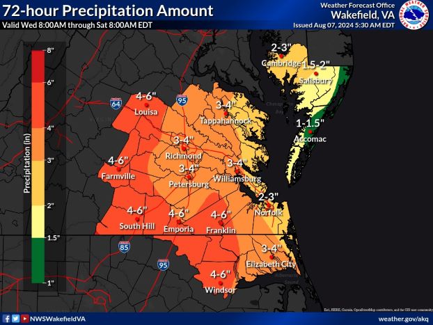
A look at how much rain is supposed to make its way to the Farmville area over the next three days.
What about the power?
Rainfall and flooding across the state could cause transportation difficulties and power outages, officials warn. Officials with Dominion and Southside Electric Cooperative (SEC) say they’ll have work crews ready to respond, but due to weather conditions, it could take several hours to restore power in any outages.
The NWS Weather Prediction Center said Wednesday that Tropical Storm Debby was forecast to restrengthen a bit and re-curve toward the Southeast before making landfall along the central South Carolina coast Wednesday night.
“Debby is expected to produce an additional three to nine inches of rainfall with locally higher amounts, leading to maximum amounts as high as 25 inches in South Carolina and 15 inches in southeast North Carolina through Friday,” NWS officials said in their short range public discussion about the storm.
The Storm Prediction Center issued a slight risk of severe thunderstorms for portions of eastern North Carolina and southeast Virginia for Thursday with a risk of tornadoes present.
Maps issued by the NWS office in Wakefield Wednesday morning show Farmville receiving four to six inches of total rainfall, with most of the severe weather expected Thursday. A chance of thunderstorms is expected for the region on Friday.
Preparing for Debby
The governor’s office recommends residents make a plan in advance of Debby’s arrival. This plan should include a route to a safe place, how each family member will stay in contact with family and friends, and actions to take in a variety of situations. Additional planning resources are available online at vaemergency.gov/prepare/make-a-plan.
Elmore provided a VDEM checklist on how to prepare for the tropical storm, noting that it can take several days or weeks for government services and assistance to reach those in affected areas. This response is dependent on the severity of the disaster and the geographic location.
“An emergency kit is vital to sustaining your family after a disaster,” the VDEM checklist explained. “Use this checklist to build your emergency supply kit over time by adding a few items each week or month.”